


EBDRT from the Illinois Prairie Path to
IL 56 (South) Project
About
The DuPage County Division of Transportation (DuDOT) is leading a project for the East Branch DuPage River Trail (EBDRT) from the Illinois Prairie Path (IPP) to the Butterfield Road (IL 56) multi-use path. This project is in Phase I, during which preliminary engineering and environmental studies are conducted for agency and public coordination.
Please read through the following information to learn more about the project and how to share your thoughts with DuDOT.
Location
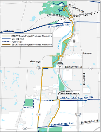
The project will extend the EBDRT approximately 4.3 miles from the Illinois Prairie Path (IPP) to the Butterfield Road (IL 56) multi-use path and provide an additional 2.0 miles of connections to the EBDRT.
Click on the image to open the full-size file in a new window.
Purpose
Once complete, the EBDRT will connect County residents and visitors to a variety of recreational, commercial, and community destinations. The trail will also connect to the larger regional non-motorized network via the Illinois Prairie Path, future I-88 Central DuPage Bikeway, and Butterfield Road multi-use path.
Spring 2026 Update
DuDOT released its proposed route for the EBDRT, called the South Project Preferred Alternative. Please scroll down to learn more about proposed route and how to submit your feedback.
Goals

Mobility:
Support local and regional multi-modal travel

Safety:
Provide a safe recreational and mobility corridor for all users

Connectivity:
Provide a path system that connects to communities, local and regional parks, and recreational and educational destinations

Recreational Benefit:
Provide a low-stress environment encouraging health and recreational use

Minimize Impacts:
Achieve a low-impact and cost-effective solution

Project Milestones

Phase I Preliminary Engineering | 2025-2027
-
Analyze existing and future conditions
-
Develop and evaluate improvement options
-
Engage with the public to obtain feedback through public information meetings and stakeholder interviews
-
Determine right-of-way and environmental impacts
-
Develop, refine, and select the Preferred Alternative
-
Obtain design approval from the Illinois Department of Transportation (IDOT) and Federal Highway Administration (FHWA)
Phase II Design Engineering | Expected to Begin in 2028
-
Complete construction plans
-
Obtain necessary permits
-
Acquire land, if necessary
Phase III Construction | (TBD)
-
Construction start date will depend on plan readiness, funding, and land acquisition (if necessary)
Public Engagement and Outreach
Public involvement is essential, as it allows stakeholders to provide input that addresses community concerns. The public has been involved throughout this Phase I study. In spring 2025, DuDOT hosted the first public information meeting (PIM #1) and issued an EBDRT survey to collect community input on trail issues, needs, and two preliminary routes: an east alternative following mostly local roads and a west alternative along IL 53. Over 200 individuals attended PIM #1, and DuDOT received 1,357 EBDRT survey responses. The project website had 1,166 unique visitors during the survey’s duration period (April 8 through May 16, 2025). The County is grateful for this impressive community response!
Following PIM #1, the project team incorporated public input into the detailed alternatives evaluation and conducted stakeholder interviews with the following entities during fall 2025:
-
Villages of Glen Ellyn and Lombard
-
Butterfield, Glen Ellyn, and Lombard park districts
-
Milton and York townships
-
Morton Arboretum
-
Forest Preserve District of DuPage County (FPDDC)
Preferred Alternative
Using feedback received from both the public and local agencies, DuDOT combined potential routes to maximize trail benefits and minimize impacts. A map of this new route, called the South Project Preferred Alternative, is shown on the right.
Click on the image to open the full-size file in a new window.
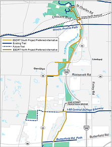
The Preferred Alternative Route is as follows:
From the IPP to Roosevelt Road (IL 38)
-
Travel south along the east side of the East Branch DuPage River using the existing FPDDC access road past the Glenbard Wastewater Authority (GWA) lagoons
-
Continue south within Tollway, FPDDC, and COMED properties,
-
Pass under IL 53 using the EBDRT east cell previously built in consideration of a potential trail and loops back over the EBDR using the existing IL 53 piers,
-
Continue south through FPDDC holdings on an existing access road west of the EBDR to IL 38
Click on the image to open the full-size file in a new window.

From IL 38 to IL 56
-
Travel south on the east side of IL 53 to IL 56
Click on the image to open the full-size file in a new window.
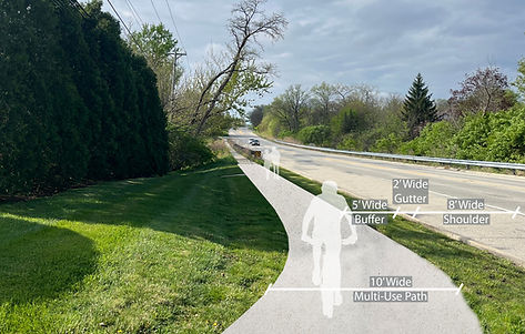
IL 53 at Marston Avenue (Looking South)
22nd Street and future I-88 Central DuPage Bikeway Connection
-
From the IL 53 and IL 56 intersection, travels east along the existing Butterfield Road path over the EBDR
-
Once east of the EBDR, turns north from IL 56 to 22nd Street (and future I-88 Central DuPage Bikeway) within ComEd property
-
Includes a new 22nd Street pedestrian bridge to provide connectivity between the Villages of Glen Ellyn and Lombard
Click on the image to open the full-size file in a new window.

ComEd Property (Looking South Toward IL 56)
Public Engagement Summaries
Public Information Meeting
-
East Alternative Aerial
-
West Alternative Aerial
Trail Survey: Concluded May 16, 2025
Share Your Feedback
DuDOT understands this is an important project to residents and visitors alike and encourages public input. Please look at the Preferred Alternative route above and share your comments.
Your input will be used to further refine the Preferred Alternative. DuDOT anticipates holding a second public information meeting in late 2026 to provide an overview of the project and schedule, present the Preferred Alternative, and obtain additional public feedback before final design approval.
Contact Us
If you have any comments or questions for the project team, please visit our Contact Page or send an email to ebdrt@dupagecounty.gov.
A project of the DuPage County Division of Transportation (DuDOT)
421 N. County Farm Road
Wheaton, IL 60187
Phone: (630) 407-6900